pointless to clean up its own sewage

The same story is true all along the banks of the river and each municipality say it would be pointless to clean up its own sewage if their neighbour up the river did not clean up their sewage.

Thursday, August 16, 2012

According to a 1973 newspaper article, there were 29 beaches on the island of Montreal.

Important: When you are viewing the photo's larger (if you click on them), click the X in the top right corner to return to this blog.


According
to a August 1973 Gazette article, there were 29 beaches on the island of Montreal.
I hope to find all their former locations and place them here so they are not forgotten.

"...instead of saving the beaches, we closed them." said Tony LeSauteur

"...if they (waterfront beaches) disappear they are gone for good." (1984)

"...in the '50 and early '60's when thousands of people from across the island flocked on hot summer days to the beach off the Cap."

"...the local shoreline (Roxboro) brought thousands of people out from Montreal...Traffic jams along Gouin Boulevard were monumental in those days, cars piled up bumper to bumper for miles along that antiquated thoroughfare."

The Gazette http://news.google.com/newspapers?id=zoY1AAAAIBAJ&sjid=1Z8FAAAAIBAJ&hl=fr&pg=3392%2C2836224


Above newspaper photo (15 August 1968 ) is of the former Roxboro beach. Where 2nd Ave North meets the Rivière des Prairies


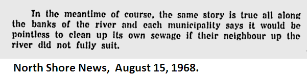
North Shore News page 2 http://news.google.com/newspapers?nid=uAPFzskPt0AC&dat=19680815&printsec=frontpage&hl=en

1947-49 Roxboro beach

Roxboro beach 2009 (not used)


The Montreal Gazette March 29, 1944 "where swimming is banned".

The Montreal Gazette August 16 , 1911 river water not fit to drink

For a history of the West Island , of  Pointe Claire : https://en.wikipedia.org/wiki/Pointe_claire "...the parish was subdivided in three côtes/ranges (east to west): St. Rémy (present-day Boulevard-des-Sources), St. Jean and St. Charles."
__________________________________________

The First Clue

1950's map L'Anse a L'Orme Beach, Cap St Jacques Beach, Crystal Beach and Roy Beach
The first clue I found to some of the old beaches names and locations was on a map (above) from the 1950's.
________________________
1952  map Riviere L'Orme, Crystal Beach and Roy Beach
I also found "Crystal Beach" and "Roy Beach" on a Federal Government map (above) of  the year 1952.
_____________________________-

1998 Carte topographique du Québec 31-H-05-200-0201 Pierrefonds  map

Beaches Crystal and Noel. Noel beach circled in red. Crystal location is wrong.


Beaches Noel and Riviera. Riviera circled in red.
_________________________________________

Found September 2013. Beach/Plage Crystal , Noel and Riviera from online National Resources Canada nrcan.gc.ca

Wednesday, August 15, 2012

List so far

... L'Anse a L'Orme Beach : Pierrefonds montreal gazette aug30, 1973
The L'Anse a L'Orme river used as a dump February 20 1975 North Shore News

September 21, 1978 North Shore News

L'Anse a L'Orme Beach 2009 (not used)
http://en.wikipedia.org/wiki/L'Anse-à-l'Orme_Nature_Park


Cap St Jacques Beach: 1950 Map

1950's map L'Anse a L'Orme Beach, Cap St Jacques Beach, Crystal Beach and Roy Beach

Cap St Jacques beach 2009, in use today.


Crystal Beach  or Lot 201  the number 201 goes to 1879 or 1924 maps defining the boundaries in the west island territory.

Crystal beach 2009 (not used)


"Housing development planned for crystal beach" May 11, 1967 North Shore News
Crystal beach on year 1924 map. Gordon and Gotch's map of the Island of Montreal compiled and drawn by Albert E. Dumont c1924 
Gordon and Gotch's map of the Island of Montreal compiled and drawn by Albert E. Dumont c1924 

Mario Grelee owned Crystal Beach May 22 , 1973 "...these area should be saved for our future needs"

Roy Beach

Roy beach or the Pierrefonds' water treatment plantPierre Leclerc, died working on the upgrade.
City worker killed in accident


Noel Beach Plage Noël

Riviera Beach  Alexander Oana owned Riviera Beach (Ste. Genevieve) May 22 , 1973

Plage Riviera/ Riviera beach link

____________

Roxboro (municipal) Beach was at 1st and 2nd Ave North  July 16, 1970 North Shore News
 and  "at the beach near 1st Avenue north" April 5 , 1973

Roxboro beachfront park 1965

Des Familles

Villagio Italiano at St Louis de Terrebonne ? not on the island?

Country Club

Oka Provincial Park Beach : Pointe Calumet beach: May not be considered a Montreal beach

Plage Jacob l'annonciation d'Oka
Cote Ste. Catherine Park
Oka Provincial park
Plage Richard, annonciation d'Oka

Laval Beach/Plage Lajeunesse   http://www.geodata.us/canada_names_maps/maps.php?featureid=EGWYH&f=144
Beach/Plage Chartrand (Laval) http://www.geodata.us/canada_names_maps/maps.php?featureid=EHRHZ&f=145  not a beach today, but it may been one long ago.


Ile Bizard Beach Technically not on the Island of Montreal ...
article http://blogs.montrealgazette.com/2010/07/08/ile-bizard-beach-ferry-to-laval-offer-respite-from-the-heat/

Ile Bizard : Martin Beach/Plage Martin a little west of the above photo.


"El Rancho" Beach in Laval West  montreal gazette aug 15, 1968 and aug 29 , 1973
 Riviere des Mille Iles / Back River

Beach/Plage Bissonnette

http://www.bing.com/maps/?v=2&cp=rmgrb28w8zrf&lvl=18.2&dir=1.57&sty=b&where1=Montr%C3%A9al-Est%2C%20QC&form=LMLTCC

Cap St Jacques beach

Goad, Chas. E, (Charles Edward), map of 1907
Goad, Chas. E, (Charles Edward), map of 1907. http://services.banq.qc.ca/sdx/cep/document.xsp?id=0003847080&eview=CARTES_PLANS/3847080/3847080_000-1.tif

Provincial Surveying and Pub. Co., Henry Whitmer Hopkins map of 1879
Provincial Surveying and Pub. Co., Henry Whitmer Hopkins (1879).
 http://services.banq.qc.ca/sdx/cep/document.xsp?id=0000174244&&epage=1&eview=CARTES_PLANS/174244/174244_006.tif

________________________________________________
Cap St Jacques 1764


1744 map with Cap St Jacques written on it.
Cap St. Jacques went lost for a few years on some maps...
Joseph Bouchette made maps of the Island of Montreal and incorrectly placed Cap St Jacques in a map of 1815 and a map of 1831
Joseph Bouchette 1815 map (wrong)

Joseph Bouchette 1831 map (wrong)


The Cap St Jacques beaches have been open and closed, and changed ownership over the years.


In 1966  the beaches were closed to the public because the Cap St Jacques land was purchased in the spring (1966) by a religious order. In an article from  The North Shore News May 11, 1967.

in 1974  January 26 the North Shore News writes of winter skiing

In 1975 the MUC  has taken over, according to April 10 North Shore News
   August 21, 1975 North Shore News

In 1977 a 210 page study from McGill University

North Shore News January 4 , 1980


Today, the entrance to the woods. Stonework is crumbling.

Entrance to the woods fixed in the summer 2014

Entrance to the woods fixed in the summer of 2014

North Shore News February 14, 1980 MUC moving ahead  $7,500,000

In 1980 the MUC bought the land for $10.5 million from the "Sisters of the holy names of Jesus and Mary" Congregation des soeurs des Saints Noms de Jesus et de Marie Sole unpolluted beach in Montreal

In 1984 it is claimed the beach is clean again. Montreal Gazette April 19 , 1984 . Remembering the past "...in the '50 and early '60's when thousands of people from across the island flocked on hot summer days to the beach off the Cap."

Pollution to blame for closed beaches. Aug 25 , 1984 newspaper article says in 1981 the beach was clean.

1986 MUC fixing up the park still, says June 19 Montreal Gazette

NOTE: The need for toilets , "in winter 1,500 skiers a day" was in one article I read.
Without toilets, the beaches will get feces on the land. People have to listen to natures call to let their bowels move. People are not machines, they eat and poop and make a mess like any other animal. Feces ends up in the water from the rain run-off.

When people leave the beach, closed due to feces contamination, the water naturally gets cleaned by mother nature and father time.

When people return to the announced clean beach they will make it "dirty" unless the city provides toilets/outhouses , cleans and prevents the garbage from accumulating.

 http://cartotheque.uqac.ca/aide_usager/Ca_PhA.php


(4) Four Montreal Beaches of today


Tuesday, May 1, 2012

Beaches In the news papers 2013-2014

2014
2014
2014 typo on www.rsma.qc.ca

A Montreal beach, Saint Helen's Island/Île Sainte-Hélène in 1938. August 16-18, 2013 Page 4 of the Metro newspaper http://reader.metronews.ca/digital_launch.aspx?eid=5fa63972-f9ed-4e10-9d20-1e45bd3f77d2
August 15, 2013 page 11 of the Metro newspaper "Une saucette pour 2017". 3 beaches/plages in Montreal, 9 beaches/plages in Vancouver , 11 beaches/plages in Toronto. http://reader.metronews.ca/digital_launch.aspx?eid=37d0c1f7-fdeb-4cb3-91f9-7057621fd619

August 19, 2013 Page 4 of the Metro newspaper "Des urbains aquatiques" http://reader.metronews.ca/digital_launch.aspx?eid=a4767e35-2e92-4df4-8606-f83837090a5e